Page 02
Terrain Map 'Tiles'
Let's take a look at the .tga file for the US_Southwest map in
detail.
The image file is comprised of 8 tiles that tell the game engine how to draw the Scenario world. This map is 100 sq. units so each tile is 601x601 pixels bringing the whole image file size to 601x4808 pixels.
The top tile is the grayscale Height Map that tells the game engine how to draw the physical landscape.
The second tile is the Terrain Map that tells the game engine to apply various textures to the physical landscape.
The third tile is the Tint map that allows you to paint on top of the Terrain Map. I have not noticed if there are any special colors that will have certain effects. It appears to be just an overlay to allow you to add details on top of the Terrain Map. White is transparent and the default color of the Tint Map.
The fourth tile is the Blend Map which I believe allows you to blend physical height features as well as terrain textures.
The purpose of the fifth tile is not known at this point and is considered to be unused.
The sixth tile is the Shoreline Map and possibly depicts certain water effects.
The seventh tile is the Tree Map that tells the game engine where to place . . . wait for it . . . trees!
The eighth tile is the Rock Map which tells the game engine where to place things other than trees like rocks, shrubs & cacti.
Now let's take a look at each tile in a little more detail.
The Grayscale Height Map
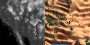
The Height Map can contain 256 various shades of gray from 0(zero) being black, to 255 being white. From a physical standpoint black would be the lowest level of ground and white would be the tip top of the highest mountain. In your paint program, since this is a full color image overall, this will be represented by equal Red, Green & Blue values such as R:0,G:0,B:0 for black, R:128,G:128,B:128 for middle gray and R:255,G:255,B:255 for white. If you take a look in the lower left of the Height Map below you will see where I have marked the end of the 0(zero) value in the ocean. Everything to the left of the white line is R:0,G:0,B:0 and then it gradually gets lighter toward the right(land). A nice gradual change will equate to a gentle slope out of the water and onto dry land like a nice beach area. As opposed to the area on the right in the red oval where you can see obvious banding and you will end up with noticable stair-stepping of your landscape as you can see in the image on right the

And here is the answer to a question presented on the Forum. It appears that sea level ends at R:48,G:48,B:48 and land begins at R:49,G:49,B:49. I made a grayscale gradiant from R:0,G:0,B:0 to R:255,G:255,B:255 and placed a gray line every 10 levels starting at R:10,G:10,B:10 and ending at R:100,G:100,B:100. You can also see that a smooth even gradiant gives a nice gentle slope.